

SEISMIC VULNERABILITY ASSESSMENT of SCHOOL BUILDINGS: GAZA STRIP SCHOOLS as a CASE STUDY
BY
S. M. Shehada 1, S. Q. Shurrab 2
1,2 Department of Civil Engineering, Islamic University of Gaza, Gaza Strip, Palestine
Abstract
This study introduces a new approach for seismic assessment of existing school buildings. The proposed approach requires minimum human effort as it can be implemented by a small team of technical construction background. The approach is based on EMS-98 scale in addition to rapid survey of architectural and structural elements of existing school buildings. The study uses 64 selected public school buildings sampled from a total of 364 schools in Gaza Strip. The results showed that 50% of the surveyed schools are classified as Vulnerability class B, while 20 % are classified as Vulnerability Class A. The results were verified using the ‘probability matrix damage’ approach and showed good satisfying convergence. The results of the study are beneficial for the responsible parties who are expected to take appropriate actions related to enhancing seismic performance of Gaza Strip schools against seismic activities, due to the fact that these school buildings not only host about 450,000 students and teachers, but also serve as emergency shelters for those who lose their homes as a result of political instabilities in the region.
Keywords: Damage, Vulnerability, EMS-98, Seismic risk, structural type.
1. Introduction:
School buildings have often collapsed during earthquakes. The 2001 Bhuj earthquake in India killed 1002 students and teachers, the 2005 Kashmir earthquake in Pakistan killed about 19,000 children, most of them in collapses of school buildings, and the 2008 Sichuan, earthquake in China destroyed about 6,898 schools killing thousands of students and teachers (López et al., 2008). In Palestine, earthquakes occur frequently where some Palestinian cities were damaged during the past hundred years. Seismicity in Palestine is mainly affected by the geodynamic processes acting along the Dead Sea Transform. The Dead Sea Transform is a left-lateral fault between the Arabia and the Sinai tectonic plates (Al- Dabbeek and El-Kelani, 2008, Fruend et al., 1968, Garfunkel, 1981, Ginsburg et al., 1981, Quennell, 1959
and 1983).
Seismic vulnerability is a measure of how susceptible a building is to damage for a given severity of the ground shaking (Borzia, B., Pinhob, R. and Crowleya, H., 2008). The building vulnerability is due to older building design codes, poor design practices and poor code enforcement (Solomn and Zheng, 2010 and Jalayer et al., 2010).A number of procedures have been outlined in the literature. The simplest and quickest way, called walk-down survey, requires only superficial data collected from a brief inspection of the building. The number of stories, vertical and plan irregularities, location of the building, age of the building, its structural system and apparent material and workmanship quality are typical parameters that are used. The purpose of rapid evaluation is to identify or rank highly vulnerable buildings that deserve further investigation. The screening method is performed without any structural analysis and takes little time to complete. Basic structural hazard scores for various building types are provided on the Rapid Visual Screening form (Aftabur and Shajib, 2012). More refined methods which include detailed analysis and take more time than Rapid Visual screening are used for the evaluation of individual buildings only. In addition, these methods can be used for rapid screening of hazardous buildings (Grandori, 1982 and Yakut, 2004).
Al-Dabbeekand El-Kelani (2008) carried out a rapid seismic vulnerability study of three Palestinian refugee camps in the West Bank, based on EMS, 1998 and FEMA 310 provisions. The results of the study showed that very heavy structural and non-structural damages to buildings in these camps are expected under the influence of moderate to strong seismic activities. Al-Dabbeek (2007) studied vulnerability, and expected seismic performance of buildings in the West Bank. Seven regions that represent the West Bank were investigated by collecting information based on site conditions, regularity and configuration of structural and architectural elements of buildings, adjacency, construction material conditions, etc. The collected data and analysis were determined according to European Macroseismic scale 1998 (EMS) and calibrated using Japanese qualitative method. The results showed that one third of the investigated buildings belong to seismic vulnerability of class A (heavy damage), whereas about 40 percent of the buildings indicate class B (moderate damage (. Lazzali and Farsi (2012) used the European Macroseismic Scale EMS-98 to define the relationship between damage and macroseismic intensity to assess the seismic vulnerability of buildings in Algiers area. Results lead to the conclusion that Algiers buildings have an average vulnerability class B. Panahi et al. (2014) evaluated the seismic vulnerability of school buildings in Tehran city based on the analytic hierarchy process (AHP) and geographical information system (GIS). The results indicated that only in 3 % of the school buildings in the study area the destruction rate will be very high and therefore need to be reconstructed. Sobaih and Nasif (2012) evaluated the seismic vulnerability of existing reinforced concrete school buildings in Egypt using a methodology that is based mainly on questionnaire forms and a computer program in order to execute the methodology.
In this study, a new approach for seismic assessment of existing school buildings in Gaza Strip has been developed, based on European Macroseismic Scale (EMS-98) scale and available literature and depends mainly on rapid survey of school building architectural and structural elements. The importance of this study stems from the fact that Gaza Strip school buildings not only host more than 450,000 students and teachers, but also serve as emergency shelters for those who lose their homes as a result of political instabilities in the region.
2. Topology of existing school buildings in Gaza Strip
There are 364 school buildings in Gaza Strip hosting about 450,000 students. The distribution amongst the directorates of Gaza Strip is shown in Table 1. These schools are mainly administered by the Ministry of Education and Higher Education (MEHE) and the United Nations Relief and Works Agency (UNRWA) and limited number of schools are considered private schools. Gaza city, being the largest city in Gaza Strip, holds the largest number of existing school buildings (135 Buildings),Khan-yonis directorate includes 73 schools, Middle Area directorate includes 52 schools, North Gaza directorate includes 60 schools and Rafah directorate includes 44 schools. Figure 1 shows the distribution of these school buildings in Gaza Strip education directorates, (MEHE,2012).
Table 1: Student distribution in Gaza Strip directorates
| Directorate | MEHE
students |
UNRWA
students |
Total number |
| North Gaza | 41,012 | 40,929 | 81,941 |
| Gaza | 99,435 | 57,615 | 157,050 |
| Middle Area | 24,320 | 44,168 | 68,488 |
| Khan-yonis | 44,670 | 39,737 | 84,407 |
| Rafah | 20,236 | 35,156 | 55,392 |
| Total | 229,673 | 217,605 | 447,278 |
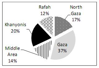
Figure 1: Distribution of school buildings in Gaza Strip directorates
3. School building structural systems:
Gaza Strip school structural systems fall into three types; concrete block bearing walls, RC building frames (Ordinary moment frames) and RC moment resisting frames (Intermediate moment frames).
MEHE Schools
• RC Building frames, which represent 78.15 % of the total number of schools.
• Concrete block bearing walls, which represent 17.23
%of the total number of schools.
• Precast frames, which represent 4.62 % of the total number of schools.
UNRWA Schools
• RC Building frames which represent 70 % of the total number of schools.
• Concrete block bearing walls which represent 12 % of the total number of schools.
• RC moment resisting frames which represent 18 % of the total number of schools.
4. Proposed Approach for Rapid Seismic Survey of School Buildings
The new proposed approach for seismic evaluation of existing school buildings is based on the European Macroseismic Scale (EMS-98) and data collected from field survey of school buildings. Fifteen structural and architectural parameters that create vulnerability are included within the survey forms. The method is summarized in the following steps.
A. Preparing the field survey forms that take into account the structural and architectural parameters, which are listed below
1. Falling hazards (El.01).
2. Adequacy of entrance and distance of staircases (El.02).
3. Vulnerable sites / poor soil condition (El.11).
4. Short columns (El.03).
5. Plan irregularity in general (El.05).
6. Vertical irregularity in general (El.07).
7. Cantilever system (El.04).
8. Soft Storey (E1.08).
9. Seismic joint (El.09).
10. Building construction material (El.10).
11. Seismic design (El.06).
12. Maintenance (El.12).
13. Large windows on one side of the classroom (El.13).
14. Standard building plans with seismic deficiencies (El.14).
15. Vulnerable forms of vernacular construction (El.15).
B. Defining school building names and their locations.
C. Selecting selected school building (64 building over Gaza Strip), using a GIS software model.
D. In situ survey of school buildings.
E. Organizing and analyzing collected data.
F. Assigning vulnerability classes for each school separately, according to the defined magnitude levels; High (H), Medium (M) and Low (L).
G. Defining damage degree for corresponding vulnerability classes of each surveyed school building.
H. Arranging expected damage grades, according to EMS-98 scale.
Selection of school building samples for purposes of field survey
Studying all of (364) existing school buildings in Gaza Strip requires immense effort and long time. GIS tool (Desktop Arc GIS software) is used in order to locate the school building samples in each directorate of Gaza Strip. A soil texture map classifies Gaza Strip for six soil texture types (Figure 2); each soil texture is defined in specified terrain area on Gaza Strip map. Existing school buildings (MEHE and UNRWA administration) locations are projected on the soil map. Then, school buildings which are enclosed in each specific texture terrain are listed in separate sheets (based on the intersection between projected soil texture map and school building locations by adopting a GIS model as shown in Figure 3.
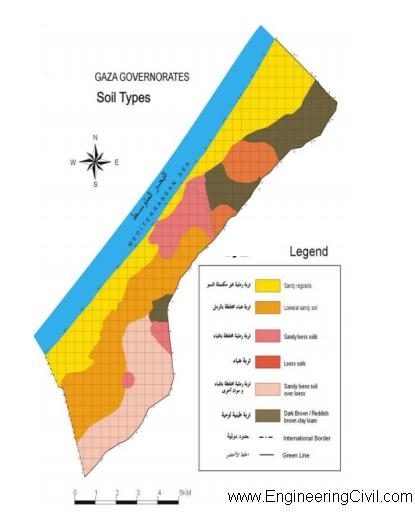
Figure(2) : Classification of soil texture profile in the Gaza Strip
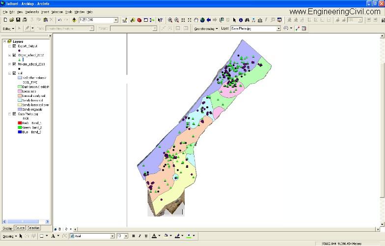
Figure (3) : Projection of existing school buildings locations (vertical and horizontal coordinates) on Gaza Strip soil texture map, using Arc GIS software (ArcGIS 9.3/9.3.1, ESRI Software, 2013
School buildings considered in the study
As discussed earlier, the selection is based on building structural system, building age and founding soil properties. Sixty four schools are chosen as shown in Figure (4).
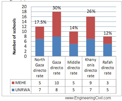
Figure 4: Selected school samples
Assigning vulnerability classes
According to the Vulnerability Classes shown in Table 2 (European Macroseismic Scale EMS-98), most of Gaza Strip schools are considered as vulnerability classes (B) to (C). For RC frame buildings without earthquake resistant design (ERD) and with serious defects (such as soft story, weak columns, lack of stiffening elements, long or very long cantilevers with heavy loads at the end, etc.), vulnerability class (B) or even (A) may be appropriate. Seismic vulnerability classes used in EMS-98 scale (A, B, C, D) are assigned for each school separately according to building structural system. Rapid survey forms are used to assign classes of vulnerability (see Table 3 in an appendix). The analysis of the considered school buildings provides the following vulnerability classes: 50% of school buildings are classified as class (B), and classes (A), (C) and (D) represe nt 20%, 22% and 8% respectively (As shown in Figure 5).
The information collected from the field survey sheets is to identify most parameters that affect identifying the attribution of the vulnerability class (Adequacy of entrance and distance of staircases, Short columns, Cantilever system…).The results show that the most observed element in surveyed schools are short columns (El.03), cantilever system (E.04) and soft story (E.08) , (See Fig 6).
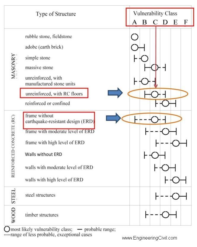
Table 2: Vulnerability Classes (European Seismological Commission, 1998)
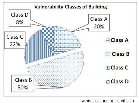
Figure 5: Vulnerability classes for existing school buildings in Gaza Strip
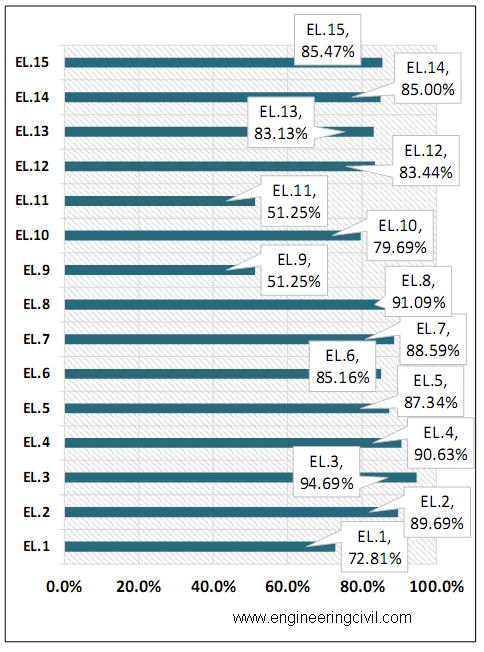
Figure 6: Fifteen structural and architectural elements observed in existing school buildings
Estimate of Damage
The distribution of damage varies from directorate to another. For each vulnerability class, the percentages of damage grade for each of the different degrees of macroseismic intensity is described. According to many studies (Dabek, 2007), (Kahane, 1988)and (Yankelevsky, 2008), Palestine could be exposed to strong earthquake once or twice during each 50 years and the intensity would be on Modified Mercalli of “VII” and “VIII”).The distribution of damage degrees (D1 to D5) for various EMS-98 intensities (V, VI, VII and VIII) for the school buildings under study are shown in (Fig. 7, 8and 9).
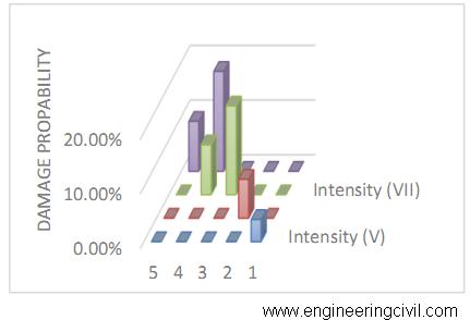
Figure 7 :Distribution of damage degrees for Vulnerability class (A)
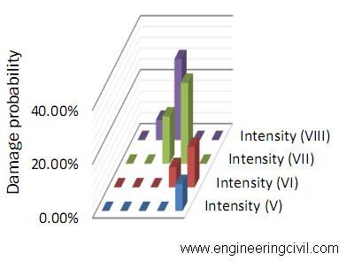
Figure 8: Distribution of damage degrees for Vulnerability class (B)
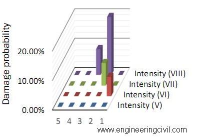
Figure 9: Distribution of damage degrees for Vulnerability class (C)
EMS-98 damage probability matrix
The damage probability matrix is a matrix which expresses the statistical distribution of the degrees of damage for a given Macroseismic intensity (Lazzali and Farsi, 2012). For purpose of convergence, damage probability is generated for class (B), which is the most dominant vulnerability class of investigated existing school building, see Fig (10).
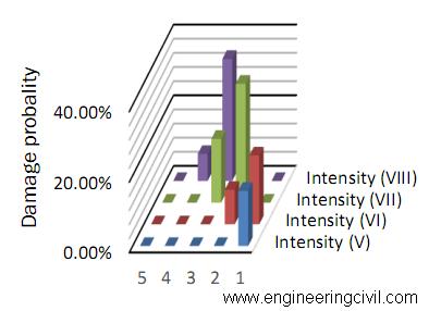
Figure 10: Damage probability matrix degrees for Vulnerability class (B)
Conclusion:
The proposed approach for assessment existing school building is based on simple procedure for the evaluation of vulnerability classes and damage distribution using a Macroseismic method (EMS-98).
Based on the results of this study, about 70 % of Gaza Strip school buildings are highly vulnerable to seismic risk (categories A and B). Moreover, about 20 % are classified as category C. Therefore, existing school buildings in Gaza Strip are vulnerable to severe damages in case of minor seismic activities. In addition, existing school buildings in Gaza Strip are highly exposed to seismic damage (EMS-98 damage grade) at low grade, where 30.0 % of school building expected to be classified as degree (2) damage. The most vulnerable forms of existing school building in Gaza Strip are short columns, soft storey and adequacy of entrance and distance of staircases. These forms tend to increase seismic risk of school building (Vulnerability).
References:
1- Aftabur, R. and Shajib, U., 2012, Seismic vulnerability assessment of RC structures: a review, Int. J Sci. Emerging Tech, 4(4), 171-177.
2- Al-Dabbeek, J. and El-Kelani R., 2008, Rapid assessment of seismic vulnerability in Palestinian refugee camps, Journal of Applied Sciences, 8(8), 1371-1382.
3- Al-Dabbeek, J., 2007, Vulnerability, and expected seismic performance of buildings in West Bank, Palestine, The Islamic University Journal (Series of Natural Studies and Engineering), 15(1), 193-217. 4- Borzia, B., Pinhob, R. and Crowleya, H., 2008, Simplified pushover-based vulnerability analysis for large-scale assessment of RC buildings, Engineering Structures 30(3), 804–820.
5- European Macroseismic Scale, 1998 (EMS-98)-Working Group M.S., European Seismological Commission, Luxembourg, Cahiers du Center Européen de Géodynamiqueet de Séismologie, Vol. 15.
6- Fruend, R., Zak, I. and Garfunkel, Z., 1968, Age and rate of the sinistral movement along the Dead Sea Rift, Nature 220, 253-255.
7- Garfunkel, Z., 1981, Internal structure of the Dead Sea leaky transform (rift) in relation to plate kinematics, Tectonophysics 80, 81-108.
8- Ginsburg, A., Markis, J., Fuchs, K., and Prodhel, C., 1981, the structure of the crust and upper mantle in the Dead Sea Transform, Tectonophysics, 80, 109-119.
9- Grandori G., 1982, Cost-benefit analysis in earthquake engineering, Proceedings of the Seventh European Conference on Earthquake Engineering, Athens, Greece.
10- Jalayer, F., Iervolino, I., and Manfredi, G., 2010, Structural modeling uncertainties and their influence on seismic assessment of existing RC structures, Structural Safety, 32(3), 220-228.
11- Lazzali, F., Farsi, M., 2012, Seismic vulnerability assessment of buildings in Algiers area, World Academy of Science, Engineering and Technology, 61, 796-800.
12- López O., Henandez J., Marinilli A., Bnilla R., Fernandez N., Dominquez J., Bala T., Cornel G., Safina S., and Vielma R., 2008, Seismic evaluation and retrofit of school buildings in Venezuela, The 14th World Conference on Earthquake Engineering, October 12-17, 2008, Beijing, China.
13- Ministry of Education and Higher Education (MEHE), 2012, Statistics about the reality of education sector for 2011/2012, Gaza Strip, Palestine.
14- Panahi M., Rezaie F. and Meshkani, A., 2014, Seismic vulnerability assessement of school buildings in Tehran city based on AHP and GIS, Natural Haza
15- rds and Earth System Sciences, 14, 969-979.
16- Shurrab, S., 2013, Evaluating seismic performance of existing school buildings in Gaza Strip, M.Sc. Thesis, Islamic University of Gaza, Palestine.
17- Sobaih, M. and Nasif, M, 2012, A proposed methodology for seismic risk evaluation of existing reinforced school buildings, HBRC Journal, 8, 204-211.
18- Solomon, T. and Zheng, L., 2010, Earthquake induced damage classification for reinforced concrete buildings, Srtructual Safety, 32(2), 154-164.
19- Quennell, A., 1959, Tectonic of the Dead Sea Transform, International Geological congress, Mexico City, 22, 385-405.
20- Quennell, A., 1983, Evolution of the Dead Sea Transform, A in Proc. 1st Jordanian Geological Conference, Abed and Khaled (Editors), Amman, Jordan, 460-482.
21- Yakut, A.,M2004, Preliminary seismic performance assessment procedure for existing RC buildings, Engineering Structures, 26(10), 1447-1461.
22- Yankelevsky. (2008). SEISMIC ARCHITECTURE AS AN ESSENTIAL
COMPONENT of the Structural Integrity of Apartment Buildings in Israel. The 14th World Conference on Earthquake Engineering (p. 8). Beijing, China: Technion- Israel institute of Technology.
23- Kahane, Y. (1988). Earthquake Risk and Insurance – Policy Considerations:The Israeli Case. The Geneva Papers on Risk and Insurance, 137-164.
24- http://www.esri.com/software/arcgis/arcgis- for-desktop.
About Paper Authors
Samir Shihada is professor in structural engineering at the department of civil engineering in the Islamic University of Gaza. He has extensive experience in teaching and practicing structural concrete design where he has published a refereed book entitled “Reinforced Concrete Design”. His research interests include structural concrete design codes, seismic design. Furthermore, he has served on several government committees dealing with building damage evaluation and engineering education.
Sallam Shurrab is an Infrastructure engineer at Qatar Ministry of Foreign Affairs (GRC) – Gaza. He received his B.Sc. in Civil Engineering and M.Sc. in Design and Rehabilitation of Structures from The Islamic University of Gaza, Palestine. He worked as a Site Engineer in Construction and rehabilitation of existing school buildings. His research interests include rehabilitation of 16 story tower building and Evaluating Seismic Performance of existing School building in Gaza Strip.
Appendix
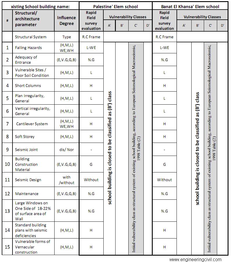
Table 3: An example of using Rapid survey forms (fifteen structural and architectural elements applied to two selected existing school buildings)
We at engineeringcivil.com are thankful to Er Sallam Shurrab for submitting the research paper on “Seismic Vulnerability Assessment of School Buildings” to us. We are hopeful that this would help others to understand and explore more on this topic.
If you have a query, you can ask a question here.
Hello, I am wondering if you can send gis shapefiles of Gaza so I can use in a Site Analysis Project.
Thank you