

By
Korukonda Vinay
Abstract
This paper describes the results of a ground water potentiality assessment and its importance in the field of trenchless technology. Water plays a vital role in the development as well as for depletion of any activity in the area . Thus, the availability of surface and ground water governs the process of planning & development of any activity. The surface water resources are inadequate to fulfill the water demand. Productivity through groundwater is quite high as compared to surface water, but groundwater resources have not yet been properly developed through exploration. Keeping this in view, the present study attempts to identify and understand groundwater potential zones of the study area using GIS. The methodology includes the construction of groundwater potentiality map using Geographical Information System (GIS) to protect the groundwater resources in the study area and to formulate recommendations to reduce the water scarcity. The ground water potentiality of the area has been assessed through integration of the relevant layers which include geomorphology, geology, slope and land use/ land cover, in ArcGIS environment. Criteria for GIS analysis have been defined on the basis of ground water conditions and appropriate weightage has been assigned to each information layer according to relative contribution towards the desired output. The ground water potential zones map generated through this model was verified with the yield data to ascertain the validity of the model developed and to find its corresponding influence in the subsurface constructions.
Introduction
Groundwater is one of the most valuable natural resources, which supports human health, economic development and ecological diversity. Groundwater is a valuable dynamic and replenishable natural resource in present day and limited in extent. Groundwater resource assessment of a region involves a detailed study of the sub-surface water, including geology and hydrogeology, monitoring and production of well data. Groundwater occurrence being subsurface phenomenon, its identification and location is based on indirect analysis of some directly observable terrain features. The identification and location of groundwater resources using remote sensing data is based on an indirect analysis of some directly observable terrain features like geomorphology, geology,slope, land use/ land cover and hydrologic characteristics .This ground water serves important basis like irrigation and other domestic uses but this groundwater may also variantly affects the ground structures.
Trenchless technology is the technology which deals with the subsurface works. As the groundwater affects the subsurface works.Thus the trenchless technology depends on ground water potentiability(ground water level) which is assessed by GIS.
An increasing number of trenchless technologies have been demonstrated and numerous projects have been successfully challenging proper utilization of gis in assessment which results problems in subsurface
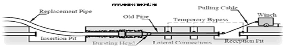
Trenchless construction :
It refers to such construction methods as tunneling, micro tunneling (MTM), and horizontal directional drilling.
Presently we are going to study ground water potentiability by a study area using GIS
Assessment of Groundwater Potentiality
The proposed study focused to evaluate the overall groundwater potentiality of the study area. The area is usually,shallow unconfined aquifers characterized by high water holding capacity used mainly for domestic and agricultural purposes. They are also located in populated areas and therefore subject to many contamination sources. The study area enclosed by 82º48’52” to 82º59’38” E latitudes and 17º54’19” to 18º05’32” N longitudes, covering an area of 191 sqkm. The climate of the area is tropical humid. The area is mainly agricultural based (more than 73% of the total area).
Assessment Methodology
In the present study, Survey of India (SoI) toposheets (65 k/13,65 j/16) of scale 1:50,000; geocoded IRS P6 LISS III images acquired on 19th February 2004; geological map (1:2, 50,000 scale), published by Geological Survey of India (1987) and field data were used for the preparation of desired themes. The thematic layers prepared includes, drainage networks, geomorphology, geology, slope and land use/ land cover of the area(described earlier). Geographic Information System (Arc GIS 8.3) was used for the preparation of thematic layers. The multi criteria evaluation techniques (MCE) were used for assigning weightages and scores to various themes and feature classes by assessing the importance of it in groundwater occurrence (Table.1). After assigning the weightages and scores to the themes and features, all the themes were converted to raster format using ‘Spatial analyst’, extension of ArcInfo ArcGIS software. While converting to raster, the scores assigned to the individual features were taken in the value field. Then, the individual themes were normalized by dividing theme weightages by 100. The ‘Raster Calculator’ option of spatial analyst was used to prepare the integrated final groundwater potential map (GPM) of the area. The map algebra (equation. 1) used in the raster calculator is,
GPM = (Geomorphology) x 0.45 + (Geology) x 0.35 + (Slope) x 0.15 + (Land use/ Land cover) x 0.05
Effect of groundwater on Subsurface works:-
Water is the tunnel’s and trenches enemy.The damaging effects of water on tunnels during their working life may be classified as:-
1) External effects (on the surroundings of the tunnels,but not affecting the structure)
2) Structural effects(affecting the structural adequacy)
3) Functional effects(affecting functional adequacy)
Result and Discussion
Groundwater potential map (GPM)
The integration of different themes through the map algebra used in the raster calculator has generated a final GPM with score varying from 2-25. The final score map was reclassified to generate the output, showing five classes of groundwater potential zones (Figure 1). The potential zones are excellent, very good, good, moderate and poor. Different potential zones, areas covered and well inventory details of each zone are given in table 2. The integrated potential zone map indicate that, alluvial plain, flood plain, with sandy silty alluvium, brown sand with gentle slope (0-7) having excellent potentiality and it covers 17.84 % of the total area. Valley flat, valley fills with lignite gritty sandstone, sandy silty alluvium with a slope (8-15) are coming under very good potential zones (32.92%). The other areas come under good, moderate and poor has covered with residual hill complex, residual hill and residual mound etc. The good potential zone covers 29.39% of the total area and 1.60% of the area by moderate potential zones. 18.25% of the total area comes under poor potential zones. Thus, the generated present ground water potential map serves as a base line data for the future exploration.
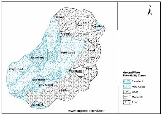
Table 1. Theme weightages and feature class score assigned by multi criteria evaluation (MCE) technique.
| Theme
|
Weightage (%) |
Feature |
Class Score |
| Geomorphology
|
0.45 | Residual hill complex
Residual hill Residual mound Pediment Valley fill |
8
5 1 10 17 |
| Geomorphology | Valley flat
Water bodies Alluvial plain |
20
25 25 |
|
| Geology
|
0.35 | Sandy silty alluvium
Brown sand Laterite Lignite-gritty sandstone Dolerite Pegmatite and quarts veins Garnet biotite gneiss Cordierite gneiss Charnockite Quartzite |
25
22 6 20 1 1 4 2 4 1 |
| Slope
|
0.15 | 0-7
8-15 16-25 26-35 >35 |
25
18 10 04 01 |
| Landuse/
Land cover |
0.05 | Paddy field
Abandoned paddy field Mixed crop Reclaimed paddy field Urban area Water body |
25
23 11 15 2 25 |
Conclusion
In the present study, an attempt has been made to generate groundwater potential map through the multi criteria evaluation techniques using the raster based GIS analysis. The GIS have proved as vital tool in delineating groundwater potential zones based on the integration of various thematic maps. The study reveals that excellent to good potential zones occupies more than 80% of the total study area. From the results it is suggested that, proper rainwater harvesting and artificial recharge methods and measures should be implemented in the moderate to nil potential zones to overcome the water scarcity problem. The present groundwater potential map will serve as a baseline data for the future development and management of water use strategies in the area.
Finally, it is concluded that the GIS technology has great potential to revolutionize groundwater monitoring and management in the future. Rapidly expanding GIS technology will play a central role in handling the voluminous spatio-temporal data and their effective interpretation, analysis, and presentation, though such applications will raise some new problems. More and more GIS based applied groundwater research is also required in conjunction with field investigations to effectively exploit the expanding potential of RS and GIS technologies, which will perfect and standardize current applications as well as evolve new approaches and applications in the future.
References:-
1. www.esri.com, www.uneca.org
2. “Groundwater: resource evaluation, augmentation, contamination, restoration, modeling and management” – M.Thangarajan
3. Trenchless Technology-Wikipedia
We at engineeringcivil.com are thankful to Sir Korukonda Vinay for submitting this research paper and helping all civil engineers understand the Assessment of Ground Water using GIS and its importance in Trenchless Technology.
If you have a query, you can ask a question here.
thats a very nce also this is important for me