

It is also called a seismic refraction survey. It is one of the types of geophysical methods used in civil engineering. We know that seismic waves have different velocities in different types of soil or rock. The seismic waves are refracted when they cross the boundary between different types of soils. The seismic refraction method is based on these two facts. This method helps us to determine the types of soil and the approximate depth of boundaries of strata or the bedrock.
The method consists of inducing impact by striking a plate on the soil with a hammer or generating shock by exploding a small charge at or near the ground surface. It radiates the shock waves which are recorded by a device called a geophone. The geophone records the time of travel of the waves. These are installed at suitable known distances on the ground in a line from the source of shock. Some of the waves known as direct or primary waves travel directly from the shock point along the ground surface. These waves are first picked by geophones. The other generated waves travel in a downward direction at various angles to the horizontal. These waves get refracted at the interface of two soil strata if they travel into a stratum at different seismic velocities. These waves are picked up by geophones. As the distance between the source of shock and the geophones increases, the refracted waves reach the geophone earlier than the direct waves. By knowing the time of travel primary and refracted waves at various geophones, the depth of various strata can be evaluated by preparing distance-time graphs and analyzing them.
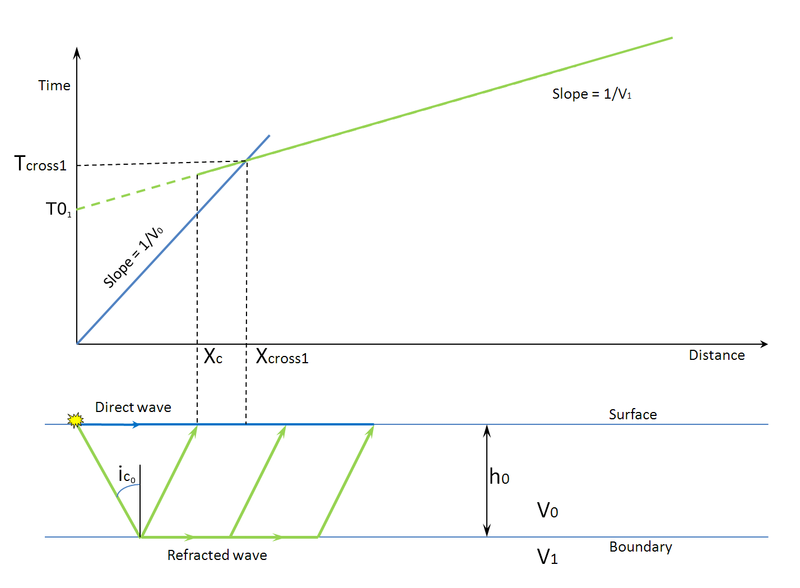
Fig 2: Graph used in Seismic refraction method
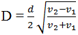
As shown in the graph, if the source-geophone spacing is less than d, the direct wave reaches the geophone earlier than the refracted wave. In this case, the time distance relationship is represented by straight-line AB. If the source-geophone distance is greater than d, the refracted wave reaches earlier than a direct wave. In this case, the time-distance relationship is shown in the graph by a straight line BC at a different slope than AB. The slopes of line AB and BC are seismic velocities and of upper and lower stratum respectively. The type of soil or rock can be determined from the knowledge of these velocities. The depth of the boundary between two strata can be estimated by the following equation.
The Seismic Refraction Method is fast and reliable in establishing profiles of different strata. The deeper layers have greater density and thus it has higher velocities and greater thickness. Different kinds of materials such as gravel, clay or, rock have characteristic seismic velocities and hence can be identified by distance-time graph.
If you have a query, you can ask a question here.